The pipeline that met every spec: Putra Heights and the 15.9 centimeters nobody saw
.jpg)
01What happened
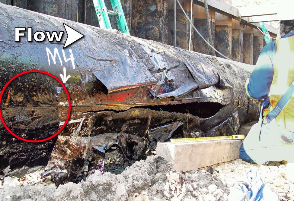
On the morning of April 1, 2025, a Petronas Gas transmission pipeline running beneath the Putra Heights suburb of Subang Jaya ruptured and ignited. The fire towered over the neighborhood for hours, damaging scores of homes and injuring residents. It became one of Malaysia's most scrutinized industrial incidents in years, with a joint investigation by the Department of Occupational Safety and Health (DOSH), police, and technical agencies, followed by a Parliamentary Special Select Committee review.
02What the investigation found
The findings, released in June 2025, are striking precisely because no one broke the rules:
- The pipe met all required technical specifications. DOSH confirmed it. No sabotage and no negligence were found.
- The root cause was soil subsidence accumulating since the pipe was laid in 2000 — soft, unstable ground beneath the line gave way over years, shifting the pipe 15.9 cm from its as-built position.
- Metallurgical analysis found the fracture occurred at a welded joint under tensile overload, with fatigue striations and stress lines — the signature of progressive, cyclic damage accumulating long before the rupture.
- The Parliamentary committee's October 2025 review concurred: soil instability plus repeated stress.
In response, DOSH directed Petronas to identify and review every high-risk segment along its 2,680-kilometer pipeline network, running from Jerteh, Terengganu to Singapore.
03The inspection gap
Putra Heights is the hardest kind of failure for a compliance-based safety model, because compliance held. Design was right, materials were right, construction was right. The threat came from outside the asset — slow ground movement, centimeter by centimeter across 25 years — in exactly the band that's hardest to monitor: too slow for instrumentation alarms, too subtle for an untrained eye, spread across thousands of kilometers of right-of-way that patrols cover on foot and by vehicle. A patroller may walk the same corridor for years; the question is whether anyone can prove each segment was actually observed, and whether observations from different patrollers, years apart, ever add up to a trend.
How SureSight closes this gap
DOSH's directive after the incident — find and review every high-risk segment across 2,680 km — is, at bottom, an inspection-verification problem at national scale. It is the problem SureSight is built for.
Patrols you can prove. Right-of-way patrollers wear the glasses; every kilometer actually observed becomes a verified, timestamped record. Coverage gaps — the segment skipped because of weather, access, or fatigue — are visible immediately rather than presumed away. When a regulator asks "was this segment inspected?", the answer is footage, not a signature.
Eyes trained for ground movement. Subsidence announces itself in small ways: settlement depressions, ponding water, leaning markers, exposed crown, cracked pavement along the alignment. Computer vision watching through the patroller's eyes flags these indicators consistently — the same standard on kilometer 2,600 as on kilometer 1, on the last patrol of a long shift as on the first.
Trend, not snapshot. Because every verified patrol is an objective visual record bound to location, the archive becomes comparable over time. A depression that deepens across three patrols is a data point no individual patroller could have assembled from memory — and it's precisely the 25-year, 15.9-centimeter kind of change that killed this pipeline. On-prem processing keeps the entire record inside the operator's network, which matters for critical-infrastructure data.
Sources & further reading
- BERNAMA — Putra Heights Gas Explosion: DOSH Confirms Pipe Met Technical Specs
- The Edge Malaysia — Weak soil beneath gas pipeline the root cause, no criminal element found
- The Star — Ground beneath pipe gave way, says report
- Malay Mail — Petronas identifies pipeline segments for review after Putra Heights explosion
- Malay Mail — Parliamentary Special Select Committee: soil instability, repeated stress caused blast